
Agentic AI for Camera-Based HSE, Audit, and Asset Census
How NovaFlow can turn field photos, timestamps, GPS coordinates, and map locations into structured evidence for HSE audits, site inspections, and asset census workflows.
Field photos should become operational evidence
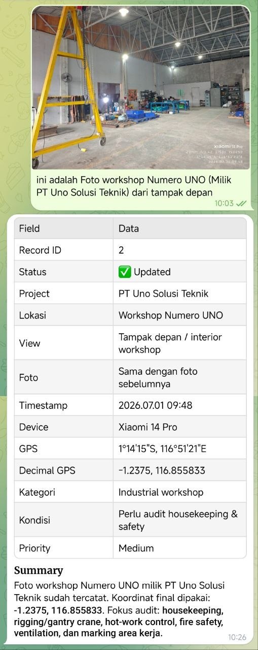
Many field teams already document work with photos. HSE officers take pictures of unsafe conditions. Auditors capture evidence during site visits. Technicians photograph panels, pumps, valves, nameplates, APAR units, hydrants, signage, stock, or work completion. The capture habit is already there.
The problem is what happens after the photo is taken. Too often, evidence lives inside WhatsApp groups, phone galleries, folders, or spreadsheet links. A few days later, the team has to ask basic questions again: where was this taken, when was it taken, who captured it, what asset does it refer to, and has anyone verified the finding?
NovaFlow can turn that pattern into a niche app: a camera-based HSE, audit, and census workflow that combines photo evidence, server timestamp, GPS coordinates, AI vision, map location, and human review. The result is not an image gallery. The result is a structured field evidence system.
The niche is bigger than one industry
This is not only an HSE product. The same pattern can support multiple field workflows where visual evidence and location context matter.
For HSE, the app can help capture housekeeping issues, blocked access, PPE observations, cable hazards, unsafe stacking, APAR placement, hydrant condition, barricade gaps, or emergency signage problems. For audit teams, it can preserve evidence with timestamp, location, reviewer status, and change history. For asset census, it can read nameplates, tag numbers, serial numbers, QR labels, and location points so the database is built from field evidence instead of memory.
That makes the product attractive as a vertical workflow app: narrow enough to deploy quickly, but flexible enough for engineering companies, property operators, warehouses, factories, utilities, construction teams, and facility management groups.
Turn safety observations into tracked findings.
Capture photo evidence, classify potential hazards, assign severity, and keep human approval in the loop.
Protect chain of evidence.
Record server timestamp, user, GPS coordinate, image hash, checklist status, and review trail.
Build asset databases from the field.
Use OCR and AI vision to extract nameplates, tags, labels, and asset candidates for supervisor verification.
Timestamp and GPS are not decoration
A field photo without context is weak evidence. It may show something real, but it does not prove enough. It can be hard to know whether the photo belongs to the claimed site, whether it was taken during the audit window, or whether it relates to the correct asset.
That is why the app should capture a trusted server timestamp, device timestamp when available, user identity, latitude, longitude, and optional location name. The map view then becomes more than a visual feature. It becomes a control layer: which area has been audited, which assets were found, where the open findings are, and which locations still need verification.
For stricter workflows, the app can also store the original image, a compressed dashboard copy, and an image hash. This gives management a clearer evidence trail without forcing field workers to write long manual reports.
Agentic AI should complete the workflow, not just describe the image
Basic computer vision answers the question: what is in this image? Agentic AI should answer a more operational question: is this evidence complete, what checklist applies, what record should be created, what needs review, and what should happen next?
The AI can read visible text, detect objects, classify hazards, estimate image quality, suggest severity, match asset tags, and decide whether the evidence is strong enough. If the photo is blurry, it can ask for a retake. If GPS is missing, it can mark the record as weaker evidence. If the finding is high risk, it can notify the supervisor or HSE officer.
This is the important shift: the app does not simply produce an AI caption. It creates a structured operational record that can be reviewed, corrected, assigned, closed, and reported.
A practical record model
The first version does not need to be complicated. Every evidence item can start with a small set of fields: evidence ID, audit type, captured by, captured at, latitude, longitude, location name, image URL, detected text, AI summary, confidence score, verification status, and reviewer notes.
Findings can be stored separately: category, severity, description, suggested action, assigned person, due date, status, and closure evidence. For asset census, the system can create asset candidates with pending verification instead of pretending OCR is always correct.
This gives the business three useful layers: immutable-ish evidence records, actionable findings, and a human review trail.
{
  "evidence_id": "ev_20260701_001",
  "workflow_type": "hse_walkdown",
  "captured_by": "field_user_042",
  "server_captured_at": "2026-07-01T04:20:00Z",
  "latitude": -1.2377,
  "longitude": 116.8529,
  "location_name": "Workshop Area A",
  "image_url": "s3://field-evidence/original/ev_20260701_001.jpg",
  "detected_text": ["APAR", "EXIT"],
  "ai_summary": "Loose cable crossing a pedestrian walkway.",
  "severity": "medium",
  "confidence_score": 0.82,
  "verification_status": "pending_review"
}
The dashboard should be map-first
For HSE, audit, and census work, a table alone is not enough. Location is part of the truth. A map-first dashboard can show evidence points, open findings, verified assets, missing locations, and areas that have not been covered yet.
Supervisors should be able to filter by date range, audit type, severity, status, user, asset tag, and location radius. A good dashboard should answer: what was checked today, where are the risky findings, which records need retake, and which assets were found but not verified?
This creates a stronger operating rhythm. Field users keep taking photos. Supervisors review exceptions. Management sees coverage and unresolved risk.
Do not let AI become the judge
For HSE and audit workflows, reckless automation is dangerous. AI can help inspect evidence, but it should not become the final authority for critical decisions.
A safer design treats AI findings as suggestions until verified. Critical consequences require human approval. Low-confidence detections go to pending review. Missing GPS is flagged, not hidden. Workers and supervisors can dispute false positives. Every status change is logged.
This matters commercially too. Clients will trust the system more if it is honest about uncertainty. A disciplined app is better than a flashy one that pretends to know more than it does.
What NovaFlow would build first
NovaFlow would start with one focused pilot, not a giant platform. Good first pilots include APAR census per building, weekly housekeeping audit, panel nameplate capture, maintenance closure evidence, construction punch-list verification, or HSE walkdown for one operating area.
The first product scope should include field photo upload, GPS and timestamp capture, original image storage, AI vision and OCR extraction, checklist rules, retake workflow, map dashboard, human verification, finding assignment, and exportable reports.
After the pilot is trusted, the same foundation can expand into more audit types, asset registers, preventive maintenance evidence, contractor control, supervisor scoring, and management reporting.
The business outcome is structured trust
The value of this niche app is not that AI can look at pictures. The value is that field evidence becomes structured, searchable, reviewable, and connected to real operational action.
For HSE teams, it means faster visibility of risk. For auditors, it means stronger chain of evidence. For asset teams, it means a cleaner census with visual proof. For management, it means fewer blind spots between what happened in the field and what appears in the report.
That is the kind of practical AI product NovaFlow should build: simple in the field, disciplined in the backend, map-aware, and human-approved at the end.